Planet Labs Restrict Satellite Imagery Access of Iranian Misuse in Ongoing Conflict
Amid escalating Iran-US tensions, Planet Labs has imposed restrictions on real-time satellite imagery access over the Persian Gulf. The move aims to prevent Iran from using the data for battle damage assessments (BDA) following recent attacks on US and allied bases. This policy change reveals the growing tension between open commercial Earth observation and security needs in modern conflict zones, where tools originally built for climate monitoring now intersect with military strategy, geopolitics, and ethics.
96-Hour Delay for Persian Gulf Satellite Imagery
Planet Labs confirmed that images captured over parts of the Persian Gulf will now be released with a 96-hour delay for most users. The restriction applies mainly to areas affected by recent Iranian strikes targeting U.S. and allied military infrastructure in the Middle East.
Authorized government clients will still receive imagery without delay for operational purposes. According to the company, the change aims to prevent hostile actors from conducting battle damage assessments (BDA) using commercial satellite data. By analyzing post-strike imagery, military planners can determine whether attacks were successful and adjust follow-up operations accordingly.
Planet Labs emphasized that the restriction is intended to reduce the risk that publicly available satellite imagery could unintentionally contribute to further escalation or loss of life.
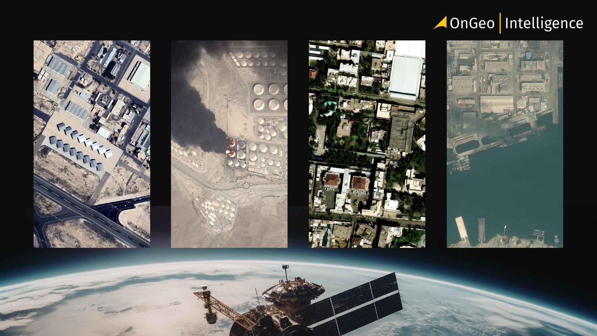
Strategic Sites Targeted in Recent Attacks
Recent satellite imagery had revealed damage at several strategic military sites connected to U.S. defense systems in the region.
These include the:
- U.S. Fifth Fleet headquarters in Bahrain,
- the AN/FPS-132 early warning radar installation in Umm Dahal, Qatar
- AN/TPY-2 mobile radar systems deployed in countries such as Jordan and the United Arab Emirates.
These radar systems are part of the broader THAAD missile defense architecture, which plays a critical role in detecting and tracking ballistic missile threats across the Middle East.
Notably, Planet Labs stated that satellite imagery covering Iran itself will remain available without delay. This asymmetrical policy is intended to limit Iran’s ability to evaluate the effectiveness of its own strikes while still allowing international observers to monitor Iranian military activity.
From Climate Mission to Strategic Intelligence Provider
Planet Labs was founded in 2010 by former NASA scientists with the mission of using satellite imagery to better understand and protect the planet. The company’s early focus was on environmental monitoring, climate research, and disaster response.
Over time, however, its role expanded significantly. Today Planet operates a constellation of more than 200 Earth observation satellites, capturing images of nearly all land areas on Earth every day. Its platform is widely used by researchers, governments, media organizations, and commercial industries such as agriculture, forestry, and energy.
The company has also secured contracts with several U.S. government agencies, including the National Reconnaissance Office (NRO) and the National Geospatial-Intelligence Agency (NGA), making it an increasingly important provider of commercial geospatial intelligence.
Satellite Imagery Becomes a Tool of Modern Warfare
The rapid expansion of commercial satellite capabilities has dramatically changed how conflicts are monitored and analyzed. Journalists and analysts can now independently verify military events using open-source satellite data, which has increased transparency in global conflicts.
At the same time, this accessibility introduces security risks. Near-real-time imagery can allow adversaries to evaluate the effectiveness of missile or drone strikes, identify damage to military infrastructure, and adjust future attacks accordingly.
The Iran–U.S. conflict has highlighted how commercial Earth observation systems can be used not only for transparency and accountability but also for strategic military intelligence.
Impact on Media, Researchers, and Industry
The new restrictions are expected to affect a wide range of users who rely on satellite imagery. News organizations frequently use satellite images to confirm battlefield developments, and the delay may slow independent verification of military claims.
Critics argue that such restrictions risk creating information asymmetry, where governments maintain privileged access to intelligence while the public and independent analysts must rely more heavily on official narratives.
A Growing Trend in the Satellite Industry
Planet Labs is not alone in restricting imagery during sensitive conflicts. Other commercial satellite providers have implemented similar policies in recent years. Companies such as Maxar Technologies have historically limited high-resolution imagery of U.S. and allied military assets.
Meanwhile, Airbus Defence and Space and several emerging Chinese satellite operators continue to provide alternative imagery sources, contributing to a fragmented global satellite intelligence landscape.
The Future of Commercial Earth Intelligence
Planet Labs’ decision illustrates a major turning point for the commercial satellite sector. Technologies originally developed to monitor climate change, environmental trends, and humanitarian crises are now deeply intertwined with military strategy.
As satellite constellations expand and data becomes increasingly accessible, companies will face mounting pressure to balance transparency, security, and ethical responsibility. The restrictions over the Persian Gulf may signal a broader shift in how commercial Earth observation providers operate during active conflicts.
In the evolving landscape of modern warfare, satellite imagery has become more than a tool for observation it is now a strategic asset shaping the flow of information in global geopolitics.
Related articles
- Why Metadata Is Essential in Satellite Earth Observation
- Satellite Images Reveal Devastating Before-After Views of Gaza City
- Satellite Imagery vs Aerial Photography: Key Differences Explained
- Israeli Strikes on Natanz: A Satellite Imagery Analysis
- Maxar Restores Ukraine’s Access to Satellite Imagery
- Beyond the Blackout: What Satellites Reveal Behind Iran's Information Shield