Construction Site Monitoring with Satellite Images
Construction projects don’t just happen overnight - they evolve over weeks, months, and sometimes years. Keeping track of progress, ensuring work follows approved plans, and monitoring environmental impact are critical, yet often challenging tasks. Site visits can be expensive, infrequent, or impractical, especially for large or remote projects.
Satellite imagery is changing how construction sites are monitored. By providing regular, objective views from space, satellite data allows stakeholders to track progress, verify compliance, and identify issues early - all without setting foot on the site.
How Satellite Imagery Supports Construction Monitoring
Satellite imagery provides construction teams, regulators, and project owners with a consistent, independent way to observe construction activity over time. Instead of relying solely on on-site inspections or self-reported updates, stakeholders can use imagery to verify what is actually happening on the ground.
Progress tracking
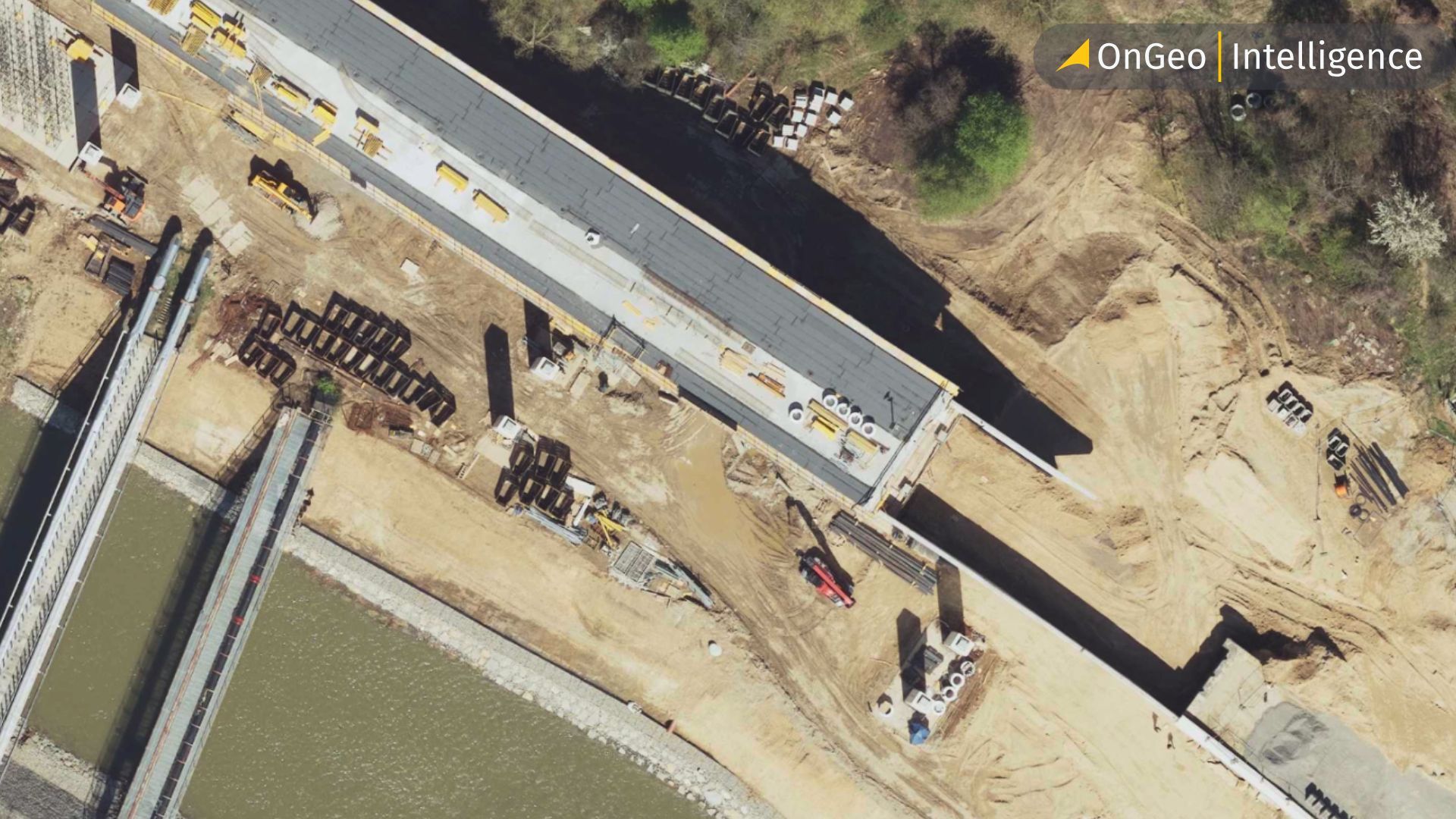
Regular satellite captures make it possible to compare images over time and measure how a site is evolving. Earthworks, foundation laying, building footprints, road access, and material stockpiles can all be tracked visually, helping teams confirm whether a project is on schedule.
Change detection
By comparing imagery from different dates, satellite data highlights where significant changes have occurred. This is especially useful for spotting unplanned expansions, delays, or deviations from approved construction plans.
Compliance and permitting oversight
Authorities can use satellite imagery to verify whether construction stays within permitted boundaries, respects buffer zones, and follows land-use regulations. This reduces reliance on frequent physical inspections while increasing transparency.
Environmental impact monitoring
Construction often affects surrounding land, vegetation, and water bodies. Satellite imagery helps identify deforestation, soil disturbance, erosion, or encroachment into protected areas, allowing issues to be addressed early.
Remote and large-scale site visibility
For large infrastructure projects or sites in remote locations, satellite imagery provides a practical way to maintain oversight without logistical challenges. Multiple stakeholders can access the same objective view of the site, improving coordination and decision-making.
Together, these capabilities make satellite imagery a powerful tool for construction monitoring, supporting more efficient project management, stronger accountability, and better environmental stewardship.
Tracking Construction Progress Over Time
One of the most powerful applications of satellite imagery in construction is the ability to monitor progress consistently over time. By comparing satellite images captured at regular intervals, project stakeholders can observe how a site evolves from initial ground clearing to final completion.
Time-series satellite imagery allows construction teams to:
- Verify whether work is progressing according to schedule
- Detect delays caused by weather, logistics, or regulatory issues
- Confirm that construction phases (excavation, foundation, structural works) are completed as planned
Unlike ground inspections, which are often infrequent and costly, satellite imagery provides an objective, repeatable record of site activity. This is especially valuable for large or remote projects where frequent site visits are impractical.
For example, monthly or bi-weekly satellite images can clearly show:
- Expansion of building footprints
- Changes in material stockpiles
- Development of access roads and supporting infrastructure
By reviewing imagery over time, decision-makers gain a transparent overview of project progress without relying solely on reports or manual updates.
Platforms like OnGeo Intelligence simplify this process by enabling users to access up-to-date satellite imagery and generate visual reports that document construction progress clearly and consistently. This makes satellite-based monitoring an effective tool for project tracking, accountability, and communication between contractors, investors, and regulators.
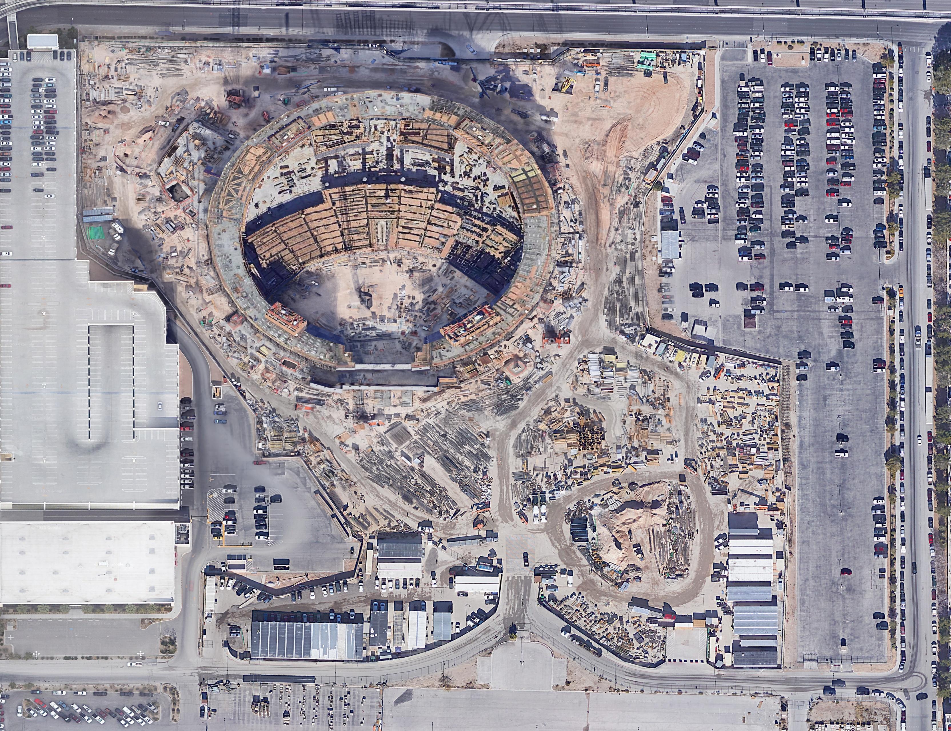
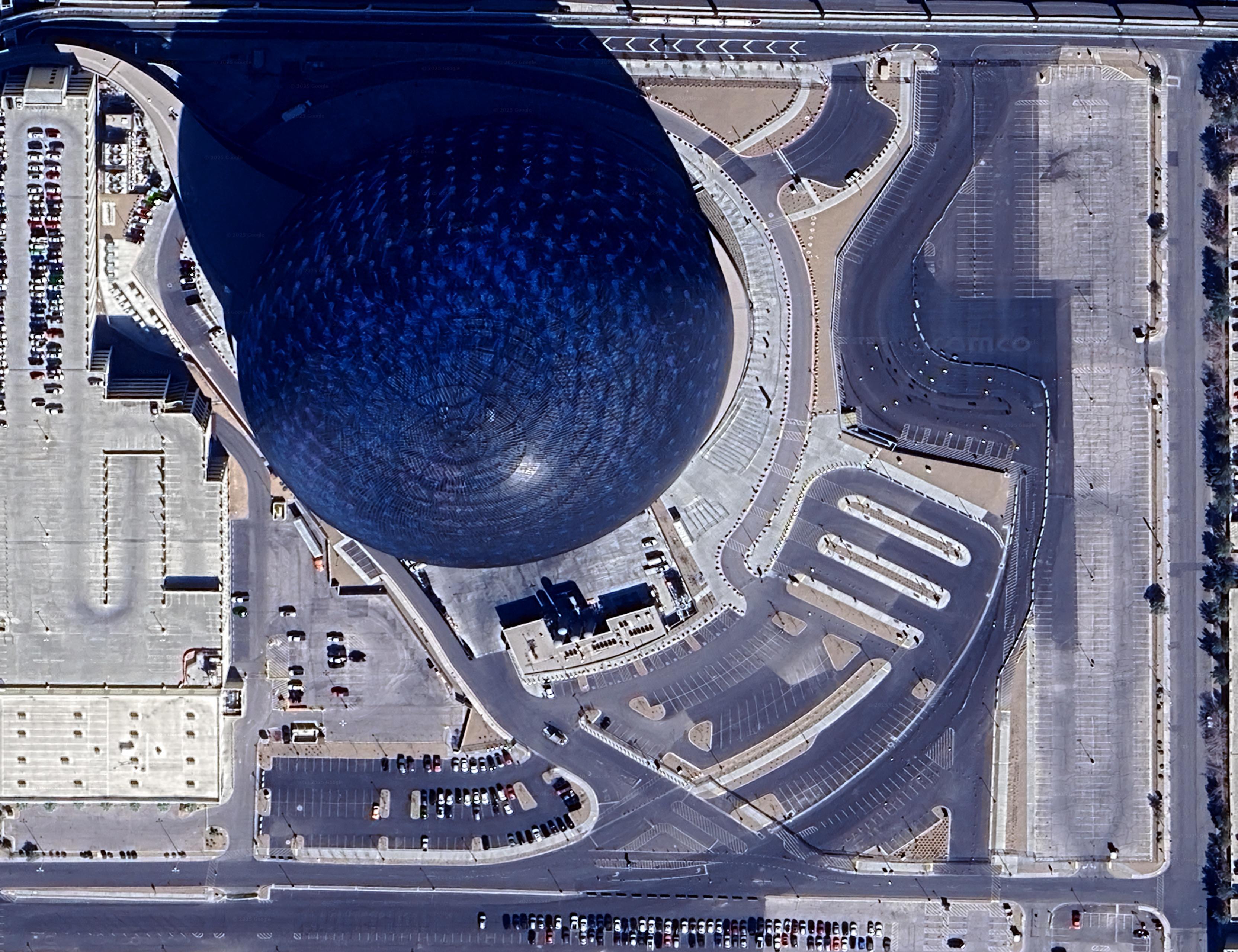
Las Vegas Sphere: comparison between 2019 and 2025.
Compliance and Regulatory Monitoring
Construction projects are subject to strict regulatory requirements covering land use, environmental protection, spatial planning, and safety standards. Satellite imagery provides an independent and verifiable way to monitor compliance throughout the project lifecycle.
By analyzing satellite data, authorities and project owners can confirm whether construction activities remain within approved boundaries and follow permitted plans. This is particularly useful for detecting:
- Unauthorized site expansion beyond approved land parcels
- Construction in restricted or environmentally sensitive zones
- Encroachment on protected areas, waterways, or public land
Satellite imagery also supports environmental compliance by revealing changes such as vegetation clearance, soil disturbance, or sediment runoff that may violate environmental impact assessments (EIAs).
Unlike on-site inspections, which are periodic and sometimes delayed, satellite-based monitoring enables continuous oversight. This reduces reliance on self-reported data and helps regulators and investors identify potential violations early before they escalate into costly legal or environmental issues.
Using platforms like OnGeo, compliance teams can access recent satellite imagery and generate standardized reports that support:
- Regulatory audits
- Environmental impact verification
- Dispute resolution and legal documentation
By integrating satellite imagery into compliance workflows, construction stakeholders gain greater transparency, accountability, and confidence that projects are progressing within legal and regulatory frameworks.
Environmental Impact Monitoring During Construction
Construction activities can significantly affect surrounding ecosystems, making environmental monitoring a critical responsibility throughout the project lifecycle. Satellite imagery provides an effective way to observe environmental changes at and around construction sites in near real time.
Using satellite data, stakeholders can monitor:
- Vegetation loss and deforestation beyond approved limits
- Soil disturbance and erosion patterns
- Changes in water bodies, drainage paths, or sediment runoff
- Impacts on nearby protected or sensitive ecological areas
By comparing satellite images over time, it becomes possible to identify whether environmental mitigation measures such as buffer zones or erosion controls are being properly implemented and maintained.
Satellite imagery is particularly valuable in regions where on-site environmental inspections are infrequent or difficult due to scale, remoteness, or security concerns. It offers an objective and consistent view that complements traditional environmental assessments and field reports.
Platforms like OnGeo Intelligence enable users to access up-to-date satellite imagery and generate clear environmental monitoring reports. These reports can support:
- Environmental Impact Assessment (EIA) verification
- Ongoing ESG and sustainability reporting
- Early detection of environmental risks or non-compliance
By integrating satellite imagery into environmental monitoring workflows, construction stakeholders can better manage environmental risks, demonstrate regulatory compliance, and reduce long-term ecological impact.
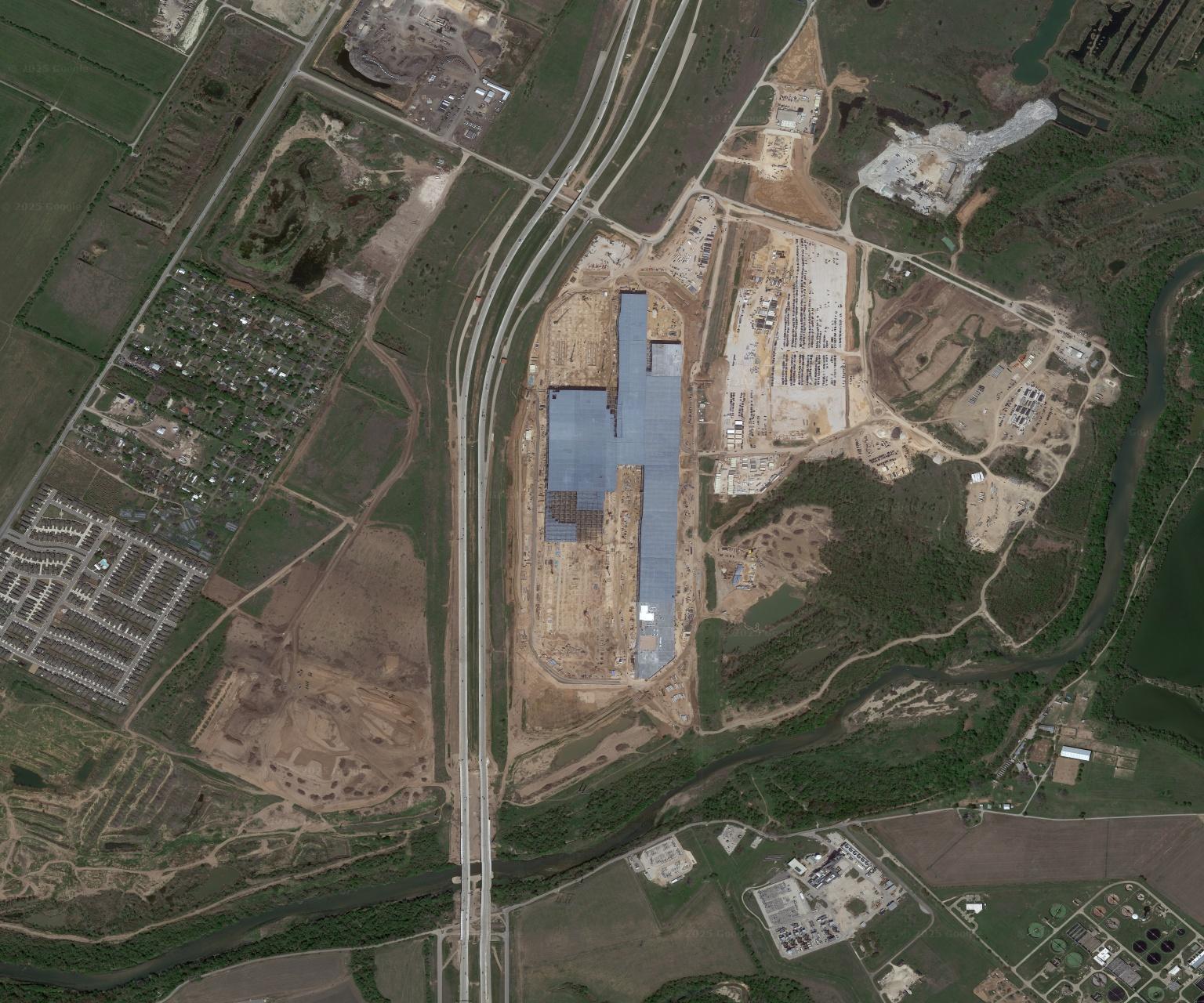
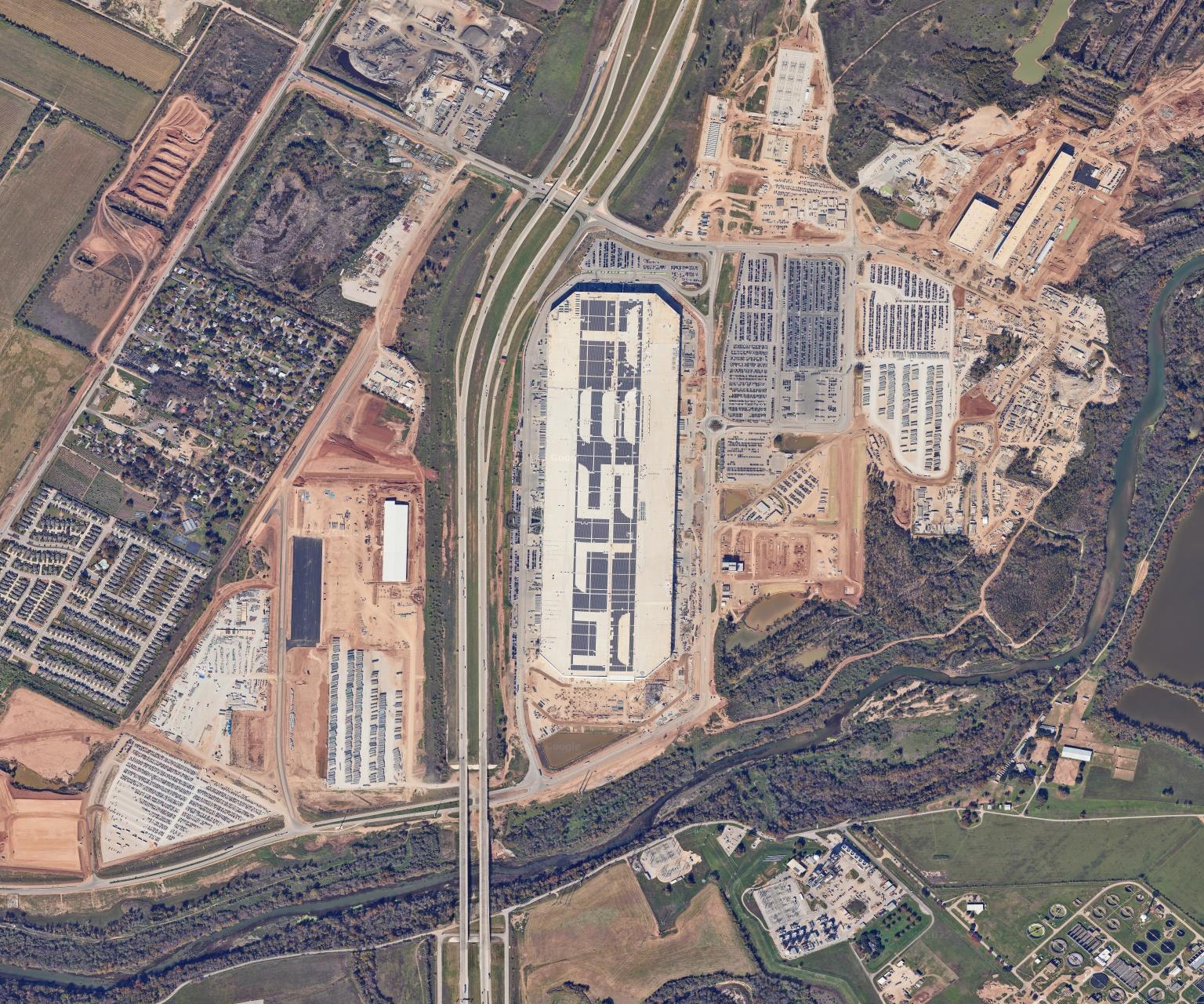
Tesla Gigafactory Texas: comparison between 2021 and 2023.
Benefits of Using Satellite Imagery for Construction Projects
Satellite imagery offers construction teams, regulators, and investors a range of practical benefits that enhance project management, oversight, and decision-making:
1. Improved Progress Tracking
Regular satellite captures allow stakeholders to monitor construction progress objectively over time, reducing reliance on manual reporting and infrequent site visits.
2. Enhanced Compliance and Regulatory Oversight
Imagery provides independent verification that construction activities remain within permitted boundaries and follow environmental and zoning regulations.
3. Environmental Risk Management
By tracking land clearing, vegetation loss, and waterway changes, satellite imagery supports sustainable construction practices and early mitigation of environmental impacts.
4. Cost and Time Savings
Reducing the need for constant on-site inspections and enabling remote monitoring helps lower operational costs while keeping projects on schedule.
5. Transparency and Accountability
Satellite reports offer clear, unbiased documentation of project activity, helping resolve disputes and maintain accountability among contractors, clients, and regulators.
6. Accessibility for Large or Remote Sites
High-resolution imagery makes it feasible to monitor projects in hard-to-reach locations, ensuring oversight without logistical challenges.
Step-by-Step Example: Tracking a Construction Project with OnGeo Intelligence
Satellite imagery makes it easy to track construction progress without visiting the site. Using OnGeo, here’s how a project can be monitored in a few simple steps:
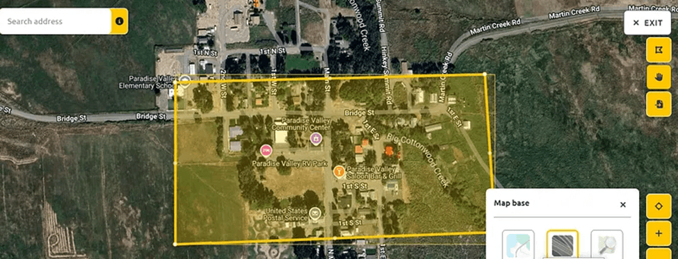
1. Select Your Project Area
Go to the OnGeo Intelligence portal and enter the location of your construction site. You can search by address, coordinates, or simply draw a boundary around the project area on the interactive map.
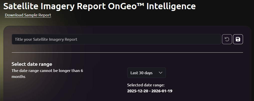
2. Choose the Date Range
Decide which dates you want to monitor. For example, select images from the start of the project and the most recent capture. OnGeo Intelligence allows you to choose specific satellite passes to see changes over time.
3. Generate a Report
Click the “Generate Report” button. OnGeo Intelligence will automatically retrieve high-resolution satellite imagery for the selected area and dates. You can also apply overlays like vegetation index or urban change detection if relevant.
4. Review the Imagery
Compare images side by side to identify visible changes such as new structures, cleared land, road construction, or material stockpiles. Use zoom and pan tools to focus on critical areas of the site.
5. Document Findings
OnGeo provides a downloadable PDF report summarizing the satellite imagery and any detected changes. Include the report in project updates, stakeholder briefings, or compliance documentation.
6. Share with Stakeholders
Reports and images can easily be shared via email or internal platforms, ensuring everyone has access to the same objective information.
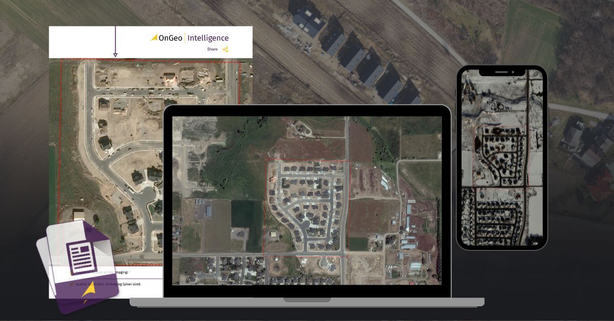
See sample Satellite Imagery Report
Read More Here: Satellite Imagery Report
Benefits of Using OnGeo Intelligence for Construction Projects
OnGeo Intelligence provides an easy and cost-effective way to monitor construction sites using high-resolution satellite imagery. The key benefits include:
- No subscription required – reports can be ordered instantly without accounts or recurring fees.
- Simple and user-friendly – clear visual reports with no GIS or technical expertise needed.
- High-resolution satellite imagery – detailed, reliable data for tracking construction progress.
- Cost and time savings – reduces on-site inspections and enables remote monitoring of multiple projects.
- Transparency and compliance support – visual documentation helps verify progress, manage risks, and ensure regulatory compliance.
Overall, OnGeo turns satellite data into practical insights that improve oversight, efficiency, and accountability in construction projects.
Satellite Imagery as a New Standard in Construction Management
Satellite imagery is transforming how construction projects are managed, monitored, and evaluated. From tracking progress over time to ensuring regulatory compliance and minimizing environmental impact, high-resolution images provide a clear, objective perspective that on-site inspections alone cannot match.
Platforms like OnGeo Intelligence make these insights accessible to everyone whether you are a project manager, regulator, investor, or contractor. By providing easy-to-read reports, free Sentinel-2 imagery options, and high-resolution data at your fingertips, OnGeo empowers stakeholders to make informed decisions, reduce risks, and maintain transparency throughout the construction process.
In 2026 and beyond, integrating satellite monitoring into construction workflows is not just a convenience it’s becoming a standard for efficiency, accountability, and sustainable development. For any construction project, big or small, satellite imagery is no longer optional; it’s an essential tool for success.
Related articles
- How to Get Live Satellite Images: Real-Time Options
- Tracking Urban Changes with SaUrban Change Detection with Satellite Imageryellite Imagery: How Change Detection Reveals City Transformations
- Investment Planning from a Bird's Eye View: Land Analysis Using Satellite Imagery
- How to Download High-Resolution Satellite Images
- How to Add Satellite Imagery to QGIS: Step-by-Step Tutorial
- Why Metadata Is Essential in Satellite Earth Observation
- From Space to Shore: How Earth Observation Satellites Help Monitor Water Quality