Where to Find Satellite Imagery from a Specific Period? Explore OnGeo Intelligence Archives!
Ever needed precise satellite imagery from a particular date? Whether you're tracking property changes, conducting environmental analyses, or gathering evidence for legal matters, access to current and historical satellite imagery is absolutely crucial. Discover how easily and quickly you can find the satellite imagery you need, all thanks to OnGeo Intelligence!
OnGeo Intelligence: Your Direct Line to Satellite Imagery Archives
OnGeo Intelligence is a game-changer, a platform that democratizes access to high-quality satellite imagery through its Satellite Imagery Report service. This groundbreaking solution makes it incredibly easy for anyone - even without specialized knowledge and the hassle of creating an account - to get the data they need.
Forget sifting through countless sources or hiring expensive specialists. With OnGeo Intelligence, you can simply and quickly find the historical satellite imagery from any period you're interested in.
How to Find and Explore Satellite Imagery from a Specific Period with OnGeo Intelligence?
The process of finding and exploring satellite imagery through OnGeo Intelligence is wonderfully intuitive, laid out in just a few straightforward steps. Best of all, browsing the archive is completely free, and there's no need to create an account!
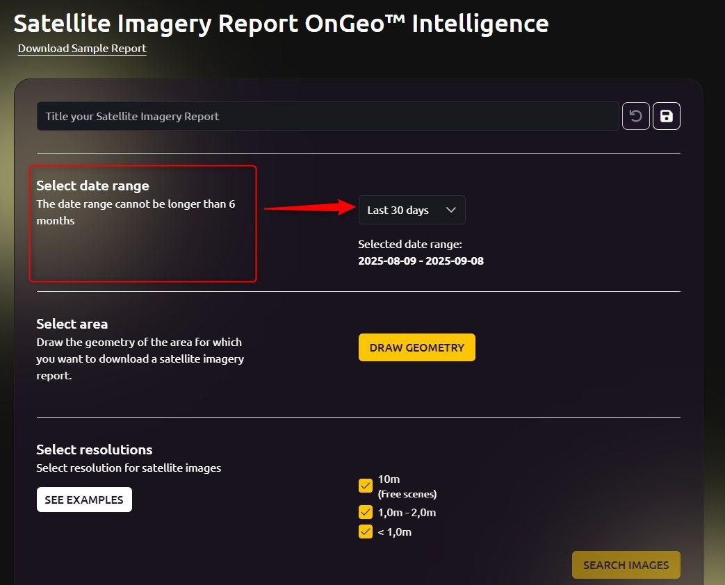
1. Pick the Dates for Your Satellite Imagery
Go to order form on OnGeo Intelligence.
Then, pinpoint the period you're interested in. You can freely choose a date range from the calendar, or use handy predefined options like "current month," "previous month," or the "last 30, 60, or 90 days."
Just a heads-up - the maximum date range you can select is 6 months; this helps ensure optimal search results and up-to-date data.
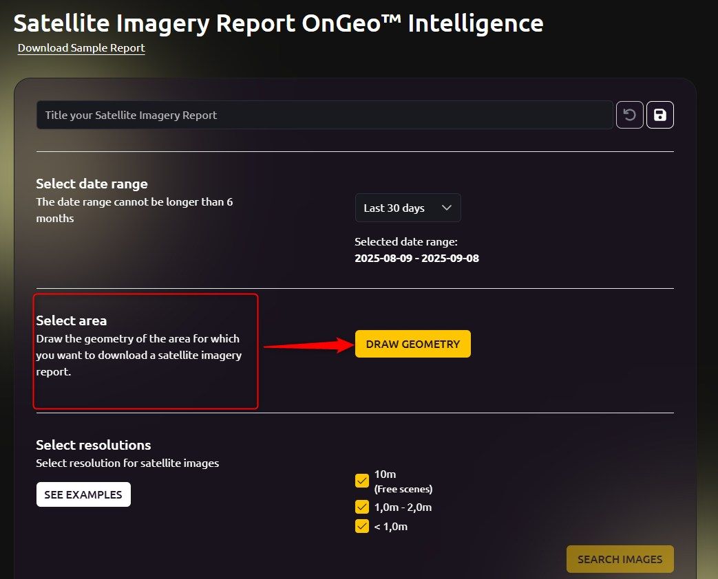
2. Define Your Area of Interest on the Satellite Map
Next, using a super intuitive drawing tool, you precisely mark the area for which you want to retrieve satellite imagery.
This could be a single plot of land, a section of a field, or even a larger urban area.
This way, you're guaranteed to find historical satellite imagery specifically for the exact spot you care about.
This whole process is quick and user-friendly, and you can even do it on your phone!
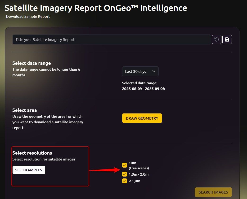
3. Select the Resolution for Your Satellite Imagery
The next step is to choose the resolution of your satellite imagery.
OnGeo Intelligence offers various options to perfectly match your needs:
- 10 m: Great for general analysis and monitoring larger areas.
- 1.0-2.0 m: Allows for a more detailed look at objects.
- Below 1 m (even 0.3 m): Lets you spot the tiniest details - ideal for super-precise applications.
After picking your desired resolution and clicking "Search images" the system instantly scours the archives of leading satellite imagery providers like Maxar and Airbus, as well as Sentinel satellite data. Within seconds, you'll get information on how many historical satellite imagery scenes were found for your area and chosen period.
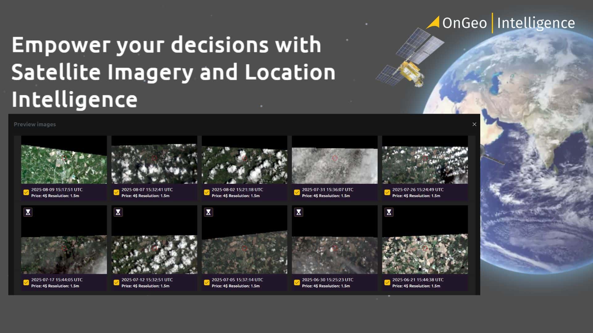
4. Browse and Select the Best Satellite Imagery
This is where the magic happens! You can now browse the thumbnails of the high-resolution satellite imagery found, assess their quality, clarity, and check for any cloud cover.
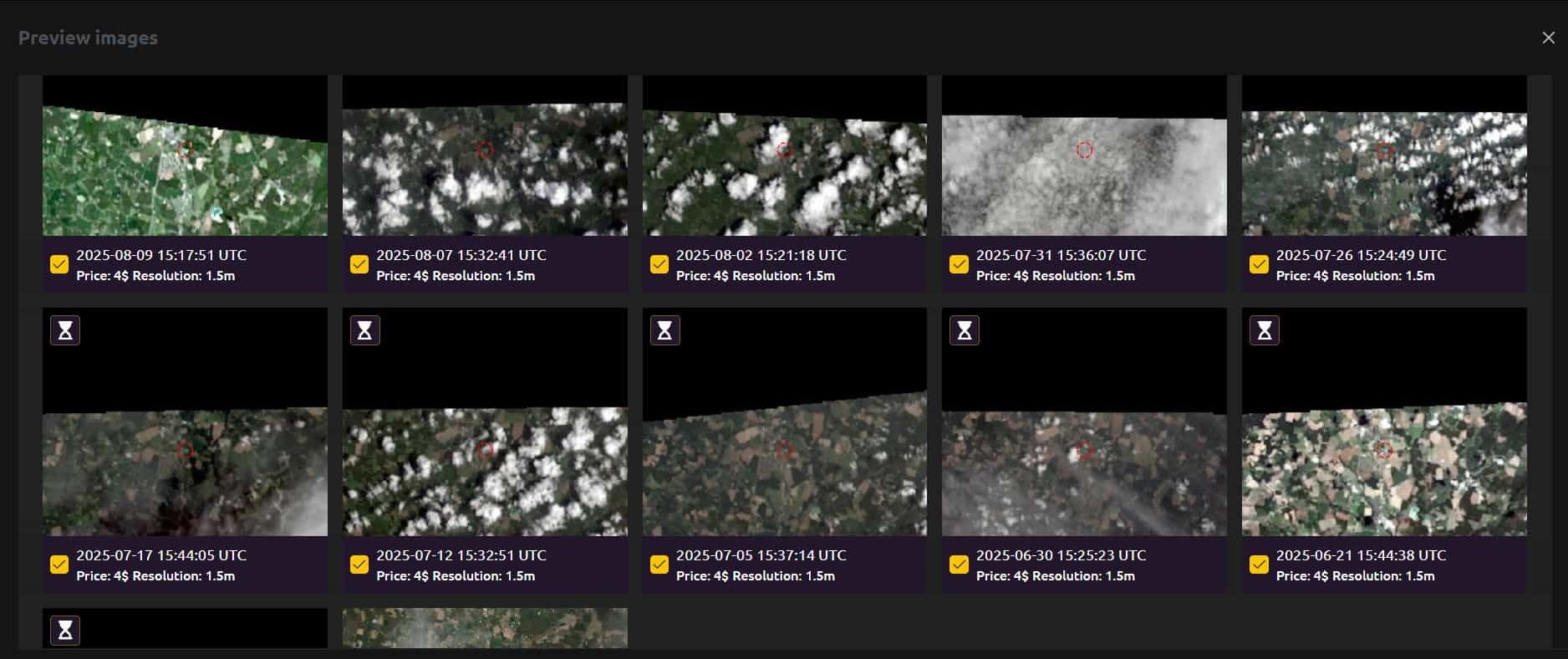
You'll also see the capture date, price, and resolution for each piece of satellite imagery. This empowers you to thoughtfully select the historical satellite imagery that best meets your expectations and then place your order. Remember, the entire process of searching and browsing thumbnails is absolutely free!
Why OnGeo Intelligence is Your Go-To for Satellite Imagery?
- Simple and Quick Access: No need for registrations or subscriptions - just straightforward access.
- High-Quality Imagery: Resolutions down to 0.3 m for truly precise analysis.
- Global Coverage: Access to satellite imagery from anywhere on Earth.
- Industry Leaders at Work: Utilizing data from Airbus Intelligence, Maxar Technologies, and Sentinel imagery.
- Accessible to Everyone: An intuitive platform that doesn't demand specialized expertise, and it's mobile-friendly too!
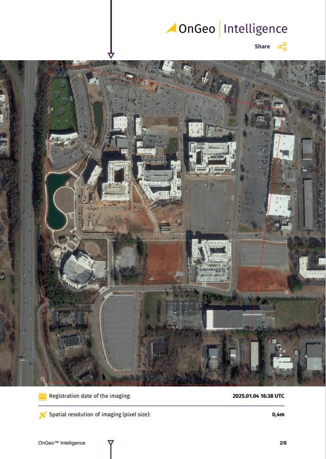
Want to dive deeper into the details? Check out Sample Report:
Why You Might Need Satellite Imagery from a Specific Period - A Month, or Even a Day?
The demand for historical satellite imagery stems from a wide array of practical applications. Sometimes, knowing the "current" state just isn't enough; the key lies in its past evolution.
Historical satellite imagery is an invaluable tool across various industries, offering precise insights into changes over time. Developers and investors leverage it to monitor construction progress, verify schedules, and document site alterations, tracking projects even on a week-to-week basis. Law enforcement and municipal services utilize these images to detect illegal activities such as unauthorized dumpsites or logging, providing accurate evidence.
Satellite imagery also plays a crucial role in resolving property disputes, serving as undeniable proof of actual land use at a specific moment. Insurance companies heavily rely on historical images to assess damages after natural disasters, comparing before-and-after shots to accurately estimate the extent of destruction and verify claims. In agriculture, farmers analyze historical imagery to monitor crop health, identify water shortages, and estimate yields at different growth stages.
Free Archive Analysis!
You don't need to create an account or provide any details just to check availability! Feel free to explore the archive of historical satellite imagery, get familiar with the search engine, and see what periods have available satellite imagery. You can even preview thumbnails of high-resolution historical satellite imagery to check their quality before you decide to buy.
Related articles
- How To Choose The Satellite Imagery For Your Needs?
- How to Obtain Satellite Imagery of Your Plot? OnGeo Intelligence Guide
- Essential Tips for Interpreting Satellite Imagery Like a Pro
- Free Maxar Imagery: Take Part in the OnGeo Promotion and Get Very High Resolution Satellite Images for Free
- Unlocking the Past: How to Search for Historical Satellite Imagery