Satellite Imagery: Definition and Applications in 2026
Satellite imagery has quietly become one of the most important technologies shaping how we understand the world. In 2026, advances in sensors, open data, and AI have transformed it into a universal tool-used to monitor climate change, track conflicts, guide urban development, and support disaster response. What was once limited to governments is now accessible to researchers, journalists, and developers around the globe. This article breaks down what satellite imagery actually is, the different types available, and the real-world applications driving its importance today.
What Is Satellite Imagery?
Satellite imagery refers to pictures of Earth captured by sensors mounted on satellites orbiting the planet. These sensors detect reflected light, emitted radiation, or other wavelengths to record what is happening on the surface below. The result is data-often visual, sometimes multispectral or thermal-that can be analyzed to understand land use, vegetation, infrastructure, water bodies, environmental change, and much more. In short, satellite imagery is a high-level, continuous way of observing Earth without being physically present.
Types of Satellite Imagery
Satellite imagery can vary widely depending on the sensors used and the type of data captured. Each type has specific strengths, making it suitable for different applications:
1. Optical Imagery
- Captures light in the visible and near-infrared spectrum, producing images similar to photographs.
- Commonly used in mapping, urban planning, infrastructure monitoring, and everyday tools like Google Maps or Apple Maps.
- Limitation: Cannot see through clouds or at night.
2. Infrared and Thermal Imagery
- Measures emitted heat from surfaces or captures infrared light reflected by vegetation and water.
- Applications include wildfire detection, drought monitoring, crop health assessment, and energy audits.
- Helps detect subtle temperature differences invisible to the naked eye.
3. Radar Imagery (Synthetic Aperture Radar, SAR)
- Uses microwave signals that can penetrate clouds, rain, and darkness.
- Ideal for disaster monitoring (floods, landslides), mapping terrain changes, and monitoring conflict areas.
- SAR imagery allows analysts to detect subtle surface movements, such as ground subsidence or deforestation.
4. Multispectral Imagery
- Captures data across several distinct wavelength bands beyond visible light.
- Useful for analyzing vegetation health, water quality, and soil conditions.
- Example: Sentinel-2 and Landsat satellites capture multiple bands for environmental monitoring and precision agriculture.
5. Hyperspectral Imagery
- Captures hundreds of narrow spectral bands, producing a detailed “spectral fingerprint” for each pixel.
- Enables precise material identification, pollution detection, and advanced agricultural or geological analysis.
- Applications include mineral exploration, environmental monitoring, and scientific research.
6. Combining Types for Maximum Insight
- Analysts often integrate optical, radar, and multispectral or hyperspectral data.
- This multi-sensor approach enhances understanding of complex phenomena like deforestation, urban sprawl, or natural disasters.
By understanding these types and their applications, users can select the right imagery for research, monitoring, or decision-making.
Key Applications of Satellite Imagery in 2026
Satellite imagery has evolved from a niche technology to a critical tool across industries and disciplines. In 2026, its applications span environmental, social, and commercial domains:
1. Climate and Environmental Monitoring
- Tracking deforestation, glacier retreat, rising sea levels, and biodiversity loss.
- Real-time monitoring of wildfires, floods, and droughts using AI-enabled change detection.
- Supporting climate research and carbon accounting for governments and NGOs.
2. Disaster Response and Early Warning Systems
- Rapid assessment of floods, hurricanes, earthquakes, and wildfires.
- Providing actionable data to humanitarian organizations, enabling efficient allocation of relief and rescue resources.
- Monitoring post-disaster recovery over time.
3. Conflict and Security Analysis
- Detecting troop movements, destroyed infrastructure, and displaced populations in conflict zones.
- Documenting human rights violations and environmental damage in areas inaccessible to journalists.
- Enhancing intelligence and situational awareness for governments and NGOs.
4. Agriculture and Food Security
- Monitoring crop health, irrigation efficiency, soil moisture, and pest outbreaks.
- Assisting farmers and governments in optimizing harvests, predicting yields, and reducing losses.
- Supporting precision agriculture through multispectral and hyperspectral analysis.
5. Urban Planning and Infrastructure Development
- Mapping new construction, urban sprawl, and transportation networks.
- Planning utilities, water management, and smart city initiatives.
- Assessing environmental impact of urban growth.
6. Business Intelligence and Market Analysis
- Tracking logistics, vehicle flows, and supply chain patterns.
- Monitoring retail activity, industrial sites, or energy infrastructure.
- Informing investment decisions and risk assessment.
7. Conservation and Wildlife Management
- Mapping protected areas and habitats.
- Detecting illegal logging, mining, or poaching.
- Supporting ecological studies and sustainable resource management.
Satellite imagery in 2026 is more than just visual data-it is actionable intelligence that informs decision-making across science, government, business, and humanitarian efforts.
Why Satellite Imagery Matters
Satellite imagery is more than just pictures from space-it is a powerful tool for understanding and responding to real-world challenges. In 2026, its importance stems from several key factors:
Global Perspective
- Satellites provide a bird’s-eye view of entire regions, countries, and ecosystems.
- This allows us to track changes that would be impossible to observe from the ground alone, from deforestation in remote forests to urban growth in megacities.
Timely and Continuous Data
- Many satellites now capture imagery multiple times per day, enabling near-real-time monitoring.
- This rapid insight is critical for disaster response, conflict monitoring, and environmental management.
Objective and Scalable Insights
- Satellite data is unbiased and consistent, offering a reliable foundation for research, policy, and business decisions.
- Analysts can quantify changes, compare regions, and monitor trends over decades.
Enabling Actionable Decisions
- Governments, businesses, and NGOs use satellite imagery to plan interventions, allocate resources, and mitigate risks.
- For example, predicting crop stress informs agricultural policies, while tracking forest loss supports conservation efforts.
Democratization of Data
- Open-source platforms and affordable commercial satellites mean that access to high-quality imagery is no longer limited to governments.
- Researchers, journalists, and small organizations can now harness satellite data for meaningful insights and storytelling.
In short, satellite imagery transforms observation into understanding, and understanding into action. In 2025, it is a cornerstone of science, governance, commerce, and humanitarian work.
How OnGeo Intelligence Applies
OnGeo makes satellite imagery accessible to users who need fast, reliable, and easy-to-understand geospatial data. While many organizations struggle with downloading raw satellite files, processing imagery, or interpreting technical layers, OnGeo simplifies the entire workflow.
Through its blog and analytical tools, OnGeo translates technical geospatial concepts into practical insights-helping readers, policymakers, journalists, and analysts understand what satellite imagery reveals and why it matters.
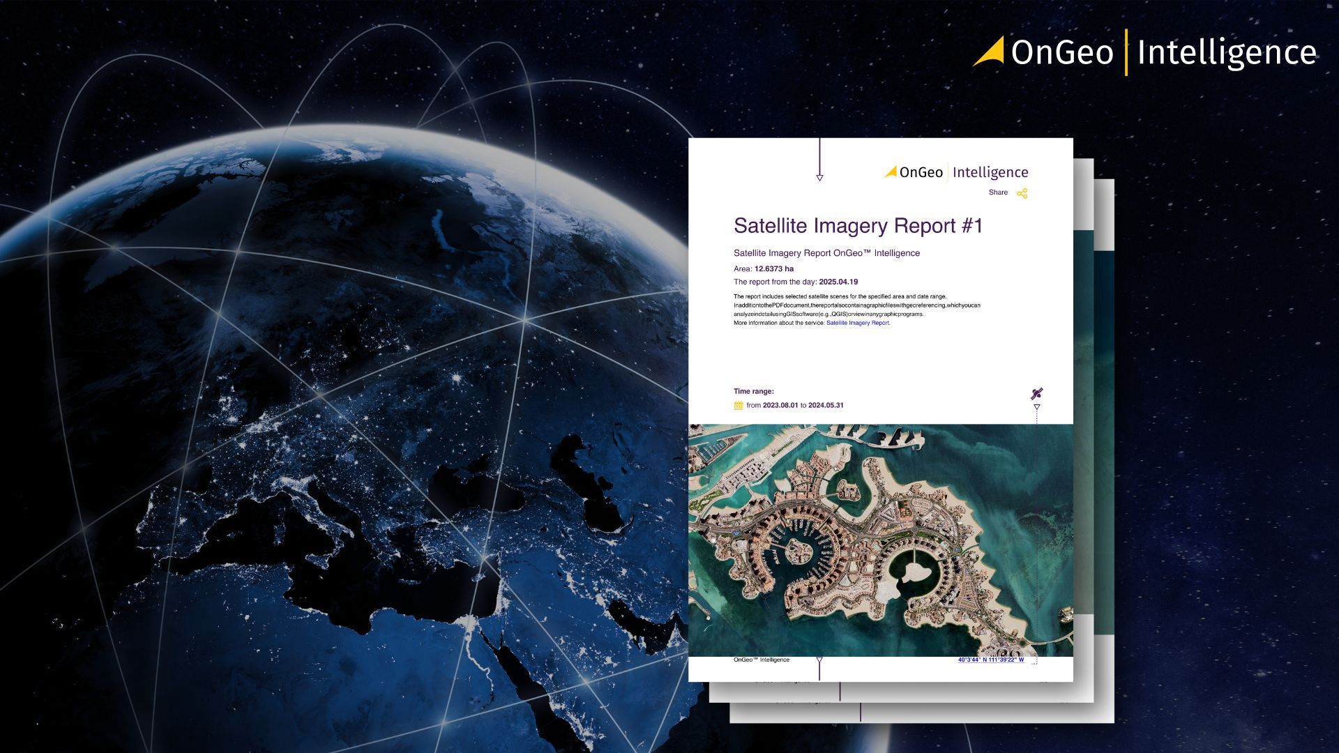
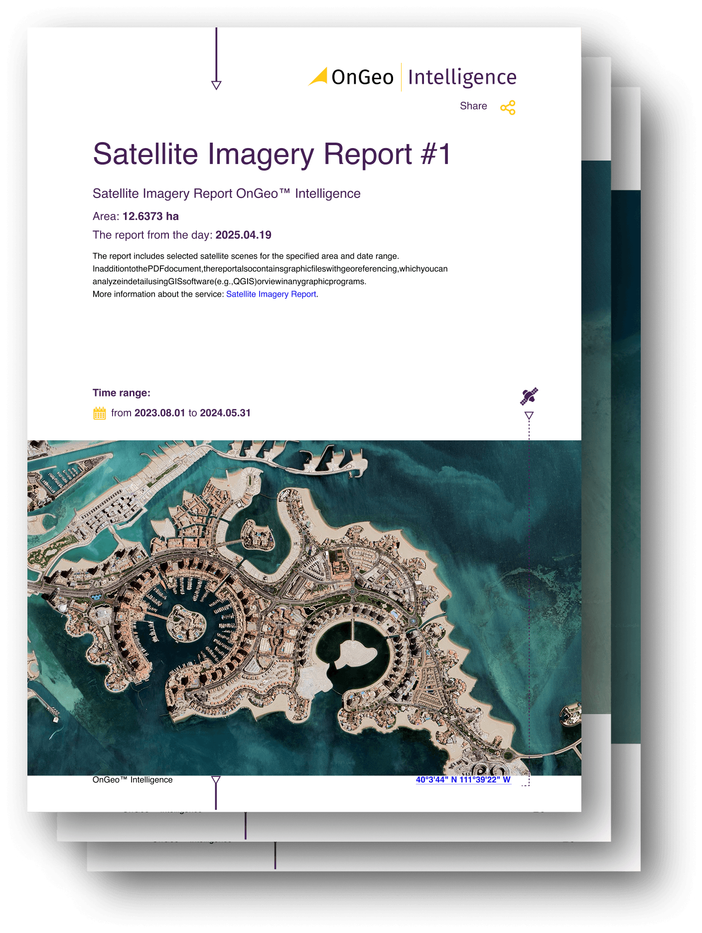
How It Works - In Brief
Use OnGeo’s interactive map to select an area of interest and define a time period.
The platform searches satellite image archives (both free - e.g. Sentinel-2 - and commercial) for available cloud-free scenes.
You choose preferred scenes, add them to cart, and place the order. For promotional codes (like their “ongeo100” code) you may get a free report at 10 m (AI-enhanced) resolution.
The report - a PDF with images and metadata - arrives via email; optionally, a full data package (georeferenced, for GIS use) is provided.
Satellite Imagery Final Thoughts
Satellite imagery has become one of the most important tools for understanding our planet in 2026. From environmental monitoring to urban planning, disaster response, security analysis, and climate research, it provides a clear, data-driven window into places that are difficult-or impossible to reach on the ground. As sensors improve and more satellites enter orbit, the accuracy, frequency, and value of this data will only continue to grow.
Platforms like OnGeo play a key role in making this information accessible. By simplifying complex datasets and presenting them in a practical, user-friendly way, they allow analysts, businesses, journalists, and everyday users to benefit from Earth observation without needing deep technical expertise.
Satellite imagery is no longer a niche scientific tool it is an essential part of how the world interprets events, manages resources, and prepares for the future.
Related articles
- How Satellite Imagery Works: From Space to Your Screen
- Monitoring air quality from space: Sentinel-4 Satellite Delivers First Data on NO2, SO2, and Ozone Levels in Europe
- Satellite Imagery vs Aerial Photography: Key Differences Explained
- Aerial photos as evidence in the case
- What Is Satellite Imagery? A Complete Beginner’s Guide
- How to Add Satellite Imagery to QGIS: Step-by-Step Tutorial
- How to Download High-Resolution Satellite Images