How Satellite Imagery Works: From Space to Your Screen
Imagine ancient skywatchers suddenly arriving in 2025. They would find a world where we no longer look upward just to wonder, but to understand - using satellites that observe Earth from thousands of kilometers above. These modern “eyes in the sky” capture data that helps us track weather, manage cities, protect ecosystems, and plan ahead.
But how does a satellite turn a view from space into the maps and insights we use every day?
This article follows that journey - from orbit to analysis - to show how raw spaceborne data becomes the vivid, information-rich imagery that shapes our view of the planet.
What You Need to Get Started
Working with satellite imagery may sound complex, but getting started is easier than ever. Whether you’re a student, GIS analyst, or a curious beginner, here are the key things you’ll need:
1. A Reliable Data Source
Start by accessing free or open satellite data platforms. Great options include:
Copernicus Open Access Hub (Sentinel imagery)
USGS Earth Explorer (Landsat data)
Google Earth Engine (for analysis-ready datasets)
NASA’s Worldview (real-time global imagery)
2. Basic GIS or Remote Sensing Software
You’ll need tools to visualize and analyze the imagery.
Free options: QGIS, SNAP, or Google Earth Engine
Professional tools: ArcGIS Pro, ENVI, or ERDAS Imagine
3. An Understanding of Key Concepts
Learn the basics of satellite sensors, resolutions (spatial, spectral, temporal, radiometric), and indices such as NDVI for vegetation analysis. A good grasp of these will help you interpret imagery correctly.
4. A Stable Internet Connection
Many datasets are large and hosted online. Cloud-based platforms like OnGeo Intelligence or Google Earth Engine make it easier to process imagery without heavy local storage.
5. A Clear Goal or Use Case
Whether you’re mapping deforestation, monitoring urban growth, or studying water bodies - define your purpose before choosing data or tools. The clearer your goal, the easier it is to find the right dataset and workflow.
6. Optional: Python or R Skills
For automation or deeper analysis, learning to work with libraries like rasterio, earthpy, or sentinelsat (in Python) can save time and unlock advanced capabilities.
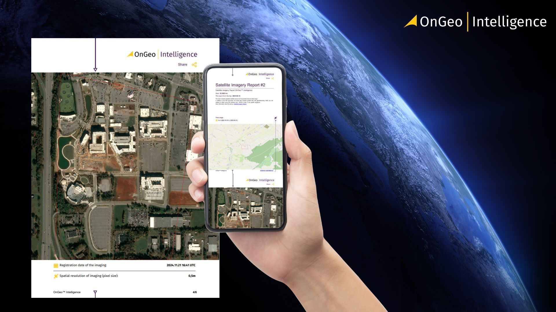
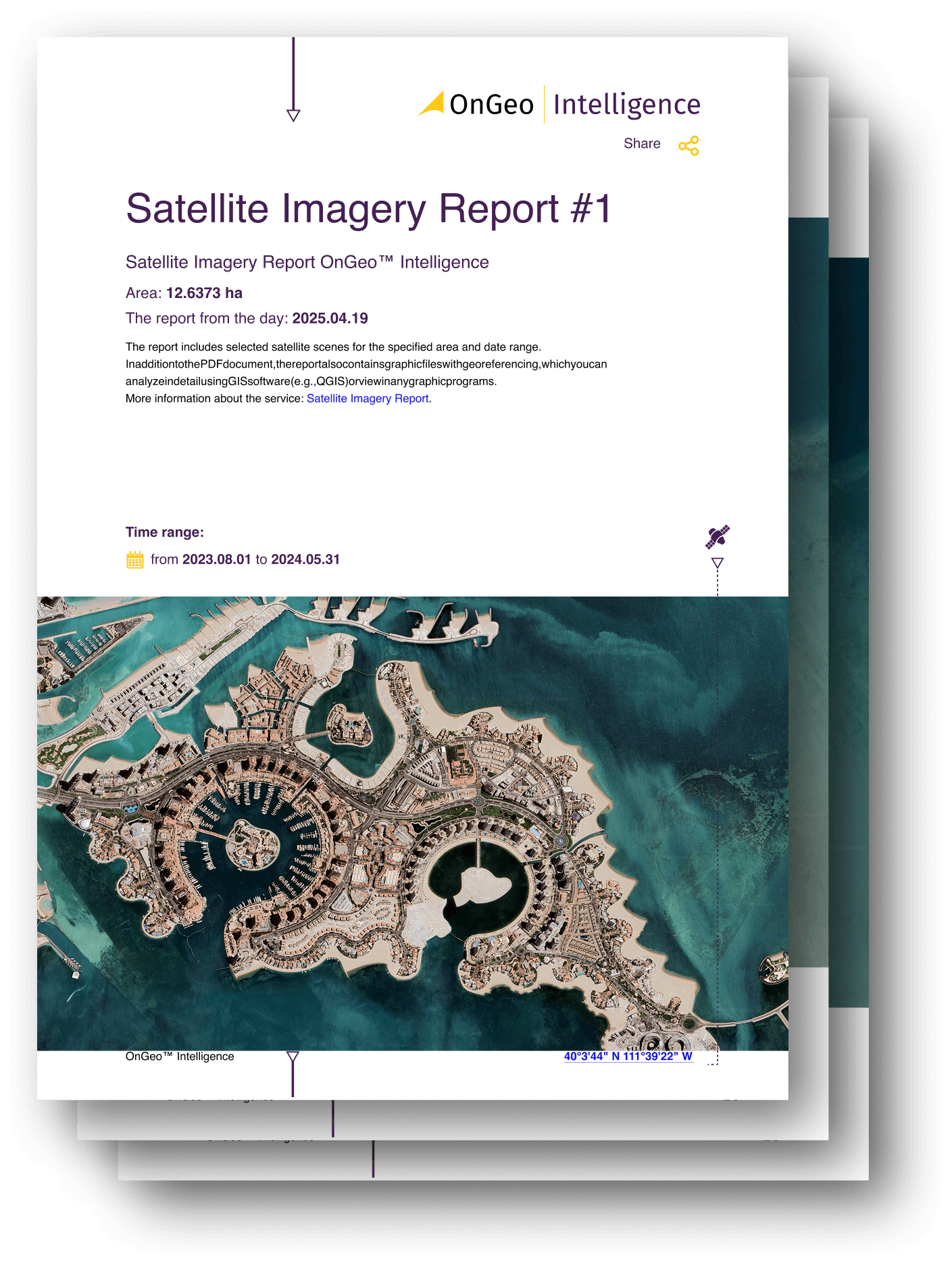
OnGeo Intelligence Satellite Imagery Report
With OnGeo Intelligence, you don’t need specialist knowledge, advanced software, or experience with complex platforms. The OnGeo Intelligence Satellite Imagery Report is designed for everyone
- Simple PDF reports: Get clear, AI-enhanced images, ready to view on your computer or phone.
- Options to fit your needs:
- Try it FREE: Get your first 10m resolution report (AI-sharpened to 2.5m) at no cost with code ongeo100.
- Need more detail? Easily order high-resolution images (down to 0.3m).
- Sentinel-2 data included: Want to dig deeper? You also get the raw, georeferenced data (like GeoTIFFs with different bands) for your GIS software.
Capturing Data from Orbit
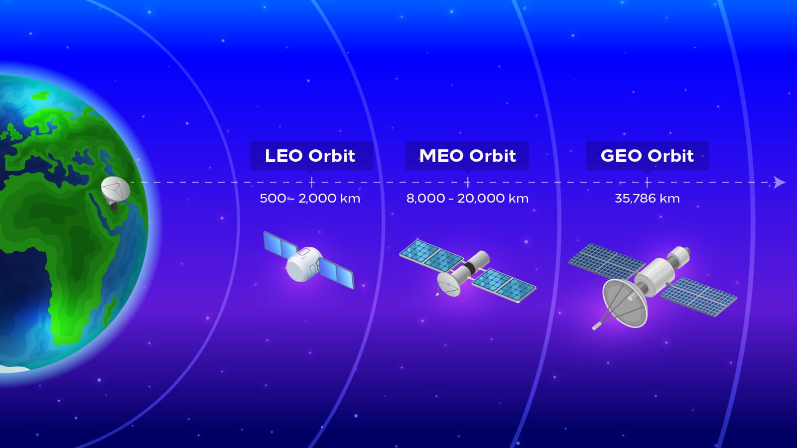
Every image starts its journey hundreds of kilometers above us. Satellites orbit the Earth in precisely calculated paths that allow them to capture every corner of the planet - from sprawling cities to remote deserts and polar ice caps. The two most common types of orbits used for Earth observation are geostationary and polar (or sun-synchronous) orbits.
Geostationary Orbit (GEO):
These satellites circle the Earth at an altitude of about 36,000 kilometers, matching the planet’s rotation. From this vantage point, they appear fixed over one spot - ideal for continuously monitoring weather systems, storms, and cloud movements. Think of them as the “watchers” that never blink.
Polar (Low Earth) Orbit (LEO):
These satellites fly much closer to the Earth - typically 500 to 1,000 kilometers above the surface - passing from pole to pole as the planet spins beneath them. Over time, they scan the entire globe in a series of swaths, capturing detailed images in high resolution. Missions like Landsat, Sentinel, and WorldView operate in these orbits, providing the backbone of modern Earth observation.
Each orbit serves a unique purpose: geostationary satellites focus on continuous coverage, while polar orbiters capture detail and precision. Together, they ensure that no part of Earth goes unseen - a living, breathing map that updates with every orbit.
Sensing the Earth’s Surface
Once in orbit, satellites act as silent observers - their sensors constantly detecting energy reflected or emitted from the Earth’s surface. These sensors don’t take pictures in the traditional sense. Instead, they record electromagnetic signals - light, heat, or radio waves - across specific wavelengths. The result is not just an image, but a dataset filled with information about what’s happening on the ground.
There are two main types of satellite sensors: optical and radar (SAR).
- Optical Sensors
These sensors detect visible and infrared light - the same spectrum our eyes can partially see. They capture the familiar natural-color images used in maps and environmental monitoring. Optical data helps identify forests, water bodies, urban areas, and crop health by analyzing how different surfaces reflect sunlight.
The downside? Clouds and darkness can block optical sensors, limiting how often satellites can “see” a location.
- Radar Sensors (SAR – Synthetic Aperture Radar)
Radar satellites, on the other hand, don’t depend on sunlight. They actively send microwave signals toward Earth and measure how those signals bounce back. This allows them to “see” through clouds, smoke, and even in total darkness - providing consistent observations regardless of weather or time of day.
SAR imagery is particularly valuable for detecting changes in terrain, monitoring floods, or assessing infrastructure damage after disasters.
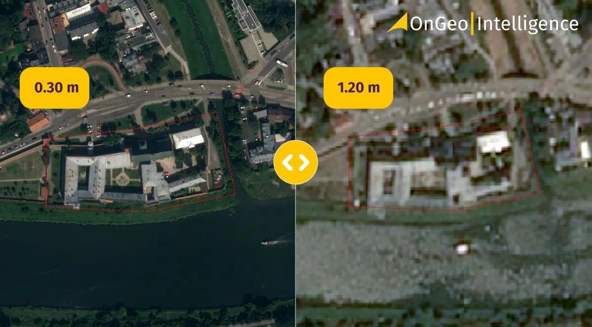
Each pixel in a satellite image represents a precise measurement of energy from a specific point on Earth - often covering an area as small as 30 centimeters in high-resolution imagery. When processed and analyzed, those pixels reveal patterns invisible to the naked eye: vegetation health, soil moisture, or even subtle ground movement after an earthquake.
Transmission and Processing
Once a satellite captures raw data from orbit, that information must travel thousands of kilometers back to Earth before it becomes anything close to a usable image. This process - known as data downlink and processing - is what transforms streams of numbers into the clear visuals and analytics we see on screens.
From Space to Ground Stations
Each satellite communicates with ground stations - specialized facilities equipped with large antennas that receive the data transmitted from orbit. Depending on the satellite’s orbit, it may only have a few short windows each day to send its data.
Once received, the information is stored as raw digital signals - not yet recognizable as images.
Calibration and Correction
Before satellite data can be used, it undergoes multiple processing steps to remove distortions caused by the atmosphere, sensor noise, or satellite motion. These key steps include:
- Radiometric correction: Adjusts for variations in sensor sensitivity and lighting conditions.
- Geometric correction: Aligns the imagery to real-world coordinates so it matches maps and other spatial datasets.
- Atmospheric correction: Removes haze and distortions caused by water vapor or dust in the atmosphere.
These corrections ensure that the image reflects true surface conditions - accurate both visually and scientifically.
Mosaicking and Enhancement
Large areas of the Earth are usually captured as multiple smaller “tiles.” These are then mosaicked together to form a continuous image. Additional enhancement techniques, such as sharpening or contrast stretching, make the data easier to interpret without altering its scientific integrity.
Cloud Platforms and Automation
Today, much of this work happens automatically on cloud-based systems such as Google Earth Engine, Copernicus Data Space, or NASA’s Earthdata. These platforms receive satellite data in near real-time, apply corrections, and make the imagery accessible to users within hours of capture.
In short, what once took weeks of manual processing can now be achieved in minutes - allowing analysts, governments, and developers to respond quickly to changing conditions on Earth.
How Users Access Satellite Imagery
After data is captured, transmitted, and processed, it finally becomes usable - ready to power the maps, models, and applications we interact with every day. This is the stage where satellite imagery truly comes to life, transforming from raw pixels into actionable insights that drive decisions across industries.
From Processed Data to Usable Products
Once cleaned and corrected, satellite imagery is organized into products such as:
- True color images – what you see on Google Maps or weather apps.
- Spectral indices – like NDVI (Normalized Difference Vegetation Index), which shows plant health.
- Change detection maps – revealing deforestation, urban expansion, or post-disaster damage.
- Elevation and terrain models – derived from radar or stereo imagery, used in engineering and hydrology.
These products are distributed through APIs, cloud platforms, or web interfaces where users can visualize, analyze, or download data for specific areas of interest.
Accessible Tools and Platforms
Modern satellite imagery is no longer limited to scientists or space agencies. Platforms like Google Earth Engine, Sentinel Hub, OnGeo Intelligence, and Esri’s Living Atlas have democratized access, allowing anyone to analyze Earth observation data in real time.
Through APIs and open datasets, developers can integrate satellite imagery into AI models, web apps, and dashboards - powering everything from environmental monitoring tools to precision agriculture systems.
Turning Imagery into Insight
The real power of satellite imagery lies in its interpretation. When combined with AI, machine learning, and GIS, satellite data becomes a decision-making engine - capable of detecting illegal mining, tracking wildfire spread, or monitoring infrastructure growth automatically.
In essence, satellite imagery has evolved from a visual curiosity to a strategic intelligence tool. What once required specialized software and expertise is now just a few clicks away, empowering users across government, business, and research to make smarter, data-driven decisions every day.
Where OnGeo Comes in
At OnGeo Intelligence, this connection is what drives its core innovation. By transforming complex satellite data into accessible insights, OnGeo empowers industries, researchers, and decision-makers to better understand our world and act with confidence.
As technology advances and small satellites, cloud processing, and AI continue to evolve, one thing remains constant - the view from above keeps getting clearer. And with it, so does our understanding of the planet we call home.
Final Thoughts
From ancient astronomers charting constellations to modern satellites mapping Earth in near real time, our perspective on the planet has evolved dramatically. Satellite imagery now stands at the center of this transformation - a bridge between observation and understanding.
What began as a tool for weather prediction and defense has become a universal language of insight. Today, satellites orbiting hundreds of kilometers above Earth provide continuous, objective data that help humanity respond to some of its greatest challenges: climate change, food security, disaster management, and sustainable development.
The process - from capturing data in orbit to turning it into actionable intelligence - represents more than just a technical achievement. It’s a testament to how far we’ve come in connecting space technology with everyday life.
Related articles
- How to get free satellite images on your phone
- What is GEOINT? The Power and Limits of Geospatial Intelligence in the Modern World
- Monitoring air quality from space: Sentinel-4 Satellite Delivers First Data on NO2, SO2, and Ozone Levels in Europe
- Why Metadata Is Essential in Satellite Earth Observation
- Satellite Imagery: Definition and Applications in 2026
- How to Add Satellite Imagery to QGIS: Step-by-Step Tutorial