
China Military Facilities: What Satellites Reveal
A decade ago, tracking military infrastructure required classified access. Today, high resolution commercial satellite imagery has changed that. Runways, missile silos, shipyards, and artificial islands leave measurable footprints visible from space.
China’s rapid military modernization is now closely documented through time stamped imagery, from South China Sea island building to inland missile fields. The key shift is visibility: satellites reveal tangible infrastructure that is difficult to hide.
Beyond static structures, analysts use pattern of life indicators, like aircraft movement or dredging activity, to assess operational readiness.
This article explores what satellite imagery reveals about Chinese military installations and how platforms like OnGeo Intelligence enable systematic analysis of infrastructure development.
South China Sea Artificial Island Bases
Few developments have demonstrated the power of satellite intelligence more clearly than China’s artificial island construction in the South China Sea. What began as submerged reefs and shoals evolved, within a few years, into fully operational military outposts all documented by commercial satellite imagery.
Strategic Location
The region is one of the world’s most critical maritime corridors. Control or influence here affects:
- Major global shipping lanes
- Fisheries and energy resources
- Regional power balance in Southeast Asia
Many of the most significant developments occurred in the Spratly Islands, a contested chain of reefs and features claimed by multiple countries.
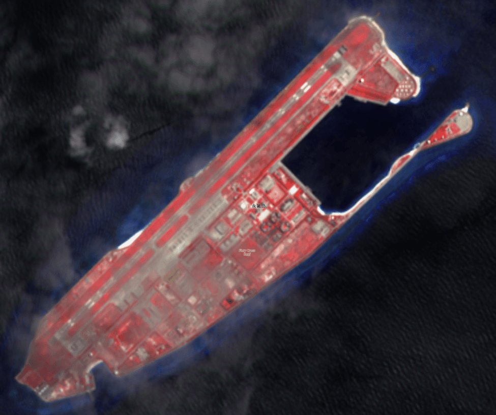
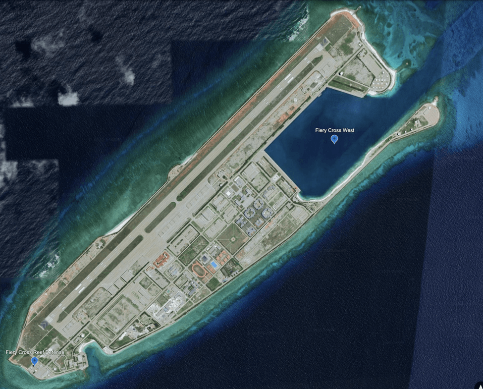
Fiery Cross Reef: The Operational Hub
Satellite imagery from platforms like Sentinel-2 and high-resolution commercial providers reveals a sophisticated military ecosystem. Analysts have documented a 3,000-meter runway, a length specifically designed to support heavy bombers and large transport aircraft. Beyond the strip, imagery shows specialized hangars, deep-water harbors, and hardened sensor installations. These features suggest that Fiery Cross is not merely a lookout point but a central command hub for sustained air and sea patrols.
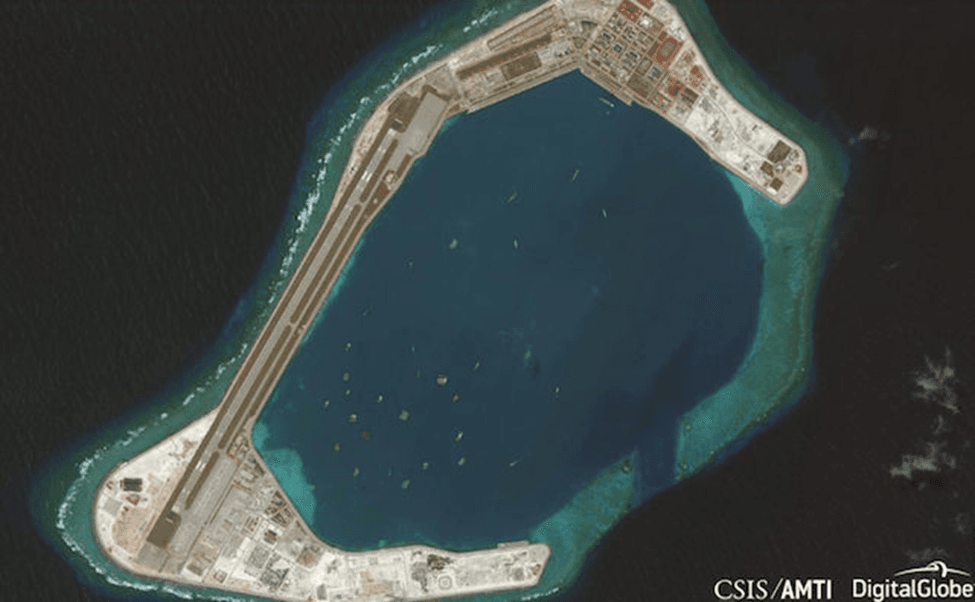
Subi and Mischief Reefs: The Defensive Perimeter
Further analysis of Subi Reef highlights extensive land reclamation that mirrors permanent airbase standards. Visible features include hardened shelters and missile defense positions, identifiable by their specific circular emplacement patterns. Meanwhile, time-series imagery of Mischief Reef shows a staggering pace of construction dredging and pier systems capable of supporting naval destroyers were completed in a timeframe that would have been impossible to track without daily orbital passes.
The Interior: Desert Silo Fields and Strategic Deterrence
While the artificial islands in the South China Sea demonstrate outward maritime projection, satellite imagery has also revealed significant strategic expansion deep within mainland China: large-scale inland missile silo fields.
These developments were primarily identified in remote desert regions, where geometric construction patterns became visible through commercial satellite platforms.
Yumen and Hami: The Geometry of Power
In regions like Yumen, commercial imagery identified over 100 circular excavation sites arranged in precise grid formations. The uniform spacing and the appearance of dome-like covers during the build phase are classic signatures of ICBM (Intercontinental Ballistic Missile) silo fields.
What Satellites Reveal in the Desert:
- Grid Spacing: Optimized for survivability against a preemptive strike.
- Construction Stages: By comparing images over months, analysts track initial ground disturbance, concrete lining, and final surface hardening.
- Support Infrastructure: The emergence of new roads and secured command facilities confirms the military nature of these sites.
This visibility has stripped away the "strategic ambiguity" that once surrounded land-based deterrents, forcing a global re-evaluation of second-strike capabilities.
How OnGeo Intelligence Facilitates Strategic Infrastructure Analysis
Satellite intelligence is only as valuable as the platform used to interpret it. OnGeo Intelligence bridges the gap between raw data and actionable insight.
Using the Satellite Imagery Report service is simple and accessible for everyone:
- Select location and time period. Pinpoint the area you want to analyze on an interactive map and specify the date range.
- Search archives. The platform automatically locates satellite images available for your selected area and period.
- Add images to your cart. Browse through the results and add your preferred scenes to your cart – all from your smartphone or desktop device.
- Enter code ongeo100 at checkout. Apply the code during checkout to unlock free access to your report with 10 m resolution images enhanced using
- Receive your report via email. Low-resolution reports are delivered within minutes, while high-resolution reports are available within 48 hours.

The Industrial Engines of Maritime Ambition: Major Naval Construction Hubs
The transformation of a regional coastal force into a global blue-water navy is perhaps most visible within the sprawling industrial complexes of Jiangnan and Dalian. Unlike clandestine operations, naval shipyards are fixed, massive, and impossible to conceal from orbital sensors. They serve as the most reliable "leading indicators" of a nation's long-term maritime strategy, providing quantifiable data on fleet composition and technological leaps years before a ship ever enters active service.
Jiangnan Shipyard (Shanghai)
Located on Changxing Island, has become the focal point of China’s most sophisticated naval projects. Satellite analysis reveals a facility optimized for modular mass production. High-resolution imagery has documented the rise of massive assembly halls where hull segments are constructed indoors away from the elements but not the satellite’s gaze. Most notably, orbital data provided the world’s first glimpses of the Type 003 aircraft carrier. Analysts tracked its progress from initial hull blocks to the installation of advanced electromagnetic catapult systems, a feat of transparency that would have been impossible in previous decades.
Dalian Shipyard: The Northern Powerhouse
Serves as a critical pillar for both domestic construction and major refitting projects. It was here that satellite imagery first captured the extensive transformation of the Varyag into China’s first carrier, the Liaoning. Today, the shipyard shows consistent activity across multiple slips, with imagery revealing the simultaneous construction of advanced Type 055 and Type 052D destroyers. The persistent presence of large hull frames visible from space allows analysts to calculate "construction velocity" the precise time it takes to move from keel-laying to launch. This metric is vital for predicting the future density of naval fleets and understanding how quickly a regional power can replace or expand its combatants.
The Rise of OSINT and Public Diplomacy
Open-Source Intelligence (OSINT) has democratized the role of the analyst. When a government denies militarizing a reef, the instant release of satellite evidence creates immediate diplomatic pressure. This "transparency tax" means that nations can no longer hide large-scale infrastructure projects, leading to faster formation of regional counter-alliances like the QUAD or AUKUS.
Deterrence vs. Preemption
Visibility works both ways. While seeing a massive fleet may deter an adversary by demonstrating overwhelming force, it also creates a "risk of preemption." If an adversary can see exactly where every silo and hangar is located, the pressure to strike first during a crisis increases, as the locations of key assets are no longer a mystery.
Conclusion: The Persistent Observer
The strategic landscape has changed. Military infrastructure once hidden behind borders is now recorded in high-resolution pixels, archived in time-series datasets, and accessible through commercial platforms.
From artificial islands in the South China Sea to inland silo grids near Yumen, satellite imagery provides a persistent, neutral observer.
In the era of commercial Earth observation and platforms like OnGeo, infrastructure development is no longer invisible.
And increasingly, geopolitics is being analyzed not just through speeches or policy documents but through what satellites can see from orbit.
Related articles
- The ISS as a Flexible Eye on Our Changing Planet
- Satellite Imagery Reveals the Aftermath of the Strike on the Penza Oil Depot
- How to Get Live Satellite Images: Real-Time Options
- How to Add Satellite Imagery to QGIS: Step-by-Step Tutorial
- Satellite Imagery: Definition and Applications in 2026
- How Satellite Imagery Works: From Space to Your Screen
- War in Sudan: How Satellite Imagery Reveals Hidden Atrocities